I spend most days in and around St. Anthony Falls, the largest waterfall on the Mississippi River. The sound of the falls rose to a crescendo in mid-July, as each second over 30,000 cubic meters of water tumbled downward.
St. Anthony Falls on July 16, 2016.
When downtown Minneapolis turns quiet on a Sunday night, the waterfall roars on. So what if I told you this natural wonder is actually a museum piece?
The falls themselves were born roughly 10,000 years ago at the end of the last ice age. Starting then, water toppled huge blocks of limestone and quarried the sandstone beneath, causing the waterfall to move upstream at about one meter per year. The waterfall started beyond today’s downtown St. Paul. From 1680 to 1887 the falls actually moved about six city blocks, from near today’s SE 8th Ave. to SE 2nd Ave. (For more, see Thomas Hickson’s great vignette). Here’s a map of the falls’ position during that time:
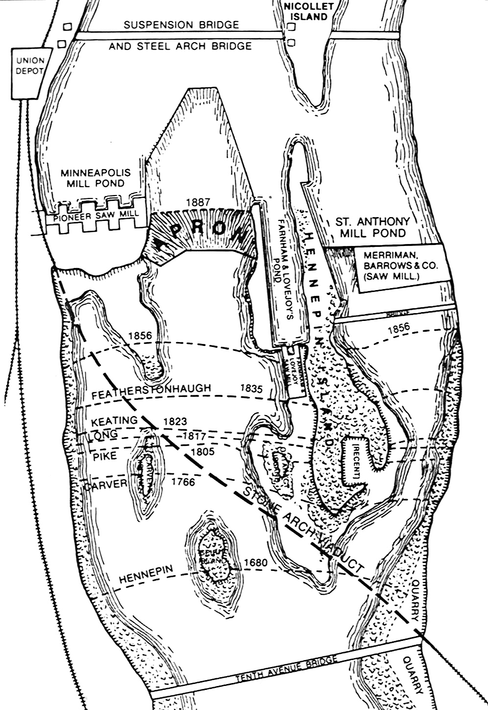
Recorded positions of St. Anthony Falls in Minneapolis (credit: Univ. of Minnesota).
The Mill City was built around the St. Anthony Falls. But engineers discovered a problem that posed an existential threat to the falls. To understand why, let’s take a deeper look at the geology.
Underneath the city of Minneapolis, there are two layers of sedimentary rock that formed in a time when “Minnesota” was a shallow ocean. These layers are the St. Peter sandstone below and a younger Platteville limestone above. The limestone supports the lip of the falls. Engineers feared that once the falls eroded back to the edge of the limestone — which by the 1870s was a short distance upstream — the falls would crumble.
And so, amid this threat of geologic proportions, the Minneapolis Milling Company, and eventually the Army Corps of Engineers, intervened. They built a wooden “apron” to guide the flow over the falls and protect the underlying rock. By 1884, engineers had successfully halted the falls’ 10,000 year journey up the Mississippi River. The river, whose surface freezes in place every winter, found its rocky base frozen in place too.

An 1884 photo of the wooden apron built beneath St. Anthony Falls (credit: Univ. of Minnesota).
In the history of development and nature, the mummification of St. Anthony Falls is an unusual chapter. The falls would have likely gone extinct on their own, but people sought to grant them immortality through engineering. The cost was great. In some cases, accounts of the falls’ original majesty are inflated. But imagine a view even half as beautiful as this:
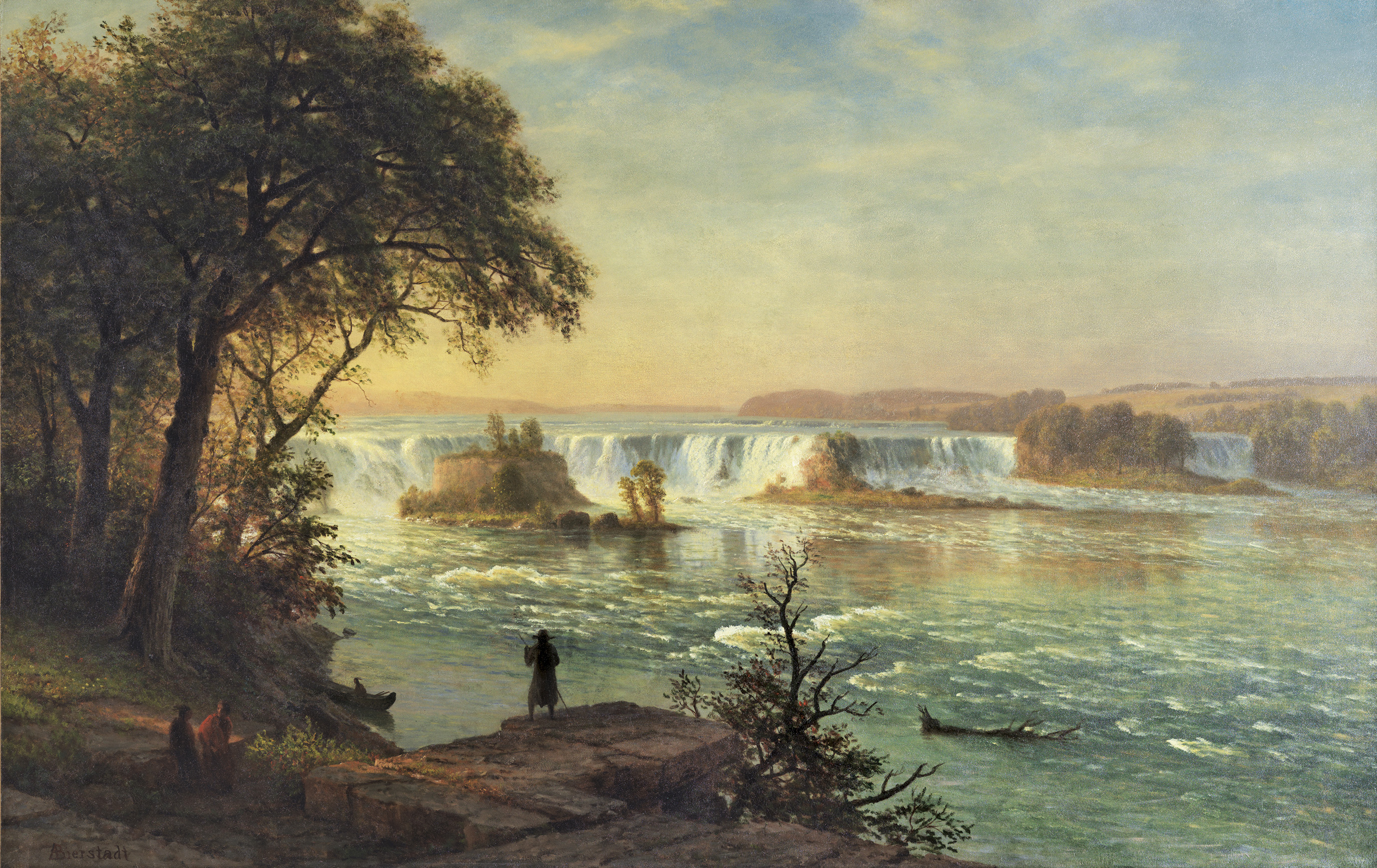
A pristine St. Anthony Falls as rendered by the painter Albert Bierstad (1830-1902) (credit: Wikipedia).
For better or for worse, the city was faced with economic calamity and took action. Minneapolitans in the 1870s ensured decades of hydroelectric and milling operations, and an enduring viewpoint for the city.
Strange as it may seem, there are interesting similarities and contrasts between the history of the falls and today’s major environmental challenges. Climate change poses a new and global set of risks, including flooding, heat waves, and shifting patterns of disease. And yet, the threats posed by the gradual rise in temperatures struggles to compete with the visceral power of an economy-sustaining waterfall on a countdown self-destruction. There are political reasons for our frustratingly slow response to climate change. But the biggest challenge to climate action arguably has nothing to do with politics. Instead, it is refining our senses to experience how the air we breathe is changing in ways we cannot see directly with our eyes.
For example, consider the work of scientists from the Scripps Institute of Oceanography that began in 1950s. Since then, generations of workers have collected measurements of carbon dioxide (CO2) from the isolated peak of Mauna Loa on the big island of Hawaii. Here’s what the data look like, with the concentration of CO2 (in parts per million, or ppm) plotted against time:

The concentration of carbon dioxide from 1958 to present, measured at Mauna Loa, Hawaii (credit: Scripps Institute of Oceanography).
This dataset represents a breakthrough in awareness. Each year the curve cycles through a rise and fall, as plants borrow and return CO2 from the atmosphere. Over several years, we also see an overall upswing the concentration of the heat-trapping gas. Through decades of careful observation, we have amplified our senses. In a stroke of synesthesia, by looking at a graph we can see the Earth breathe.
The call to connect to something bigger than ourselves does not usually come from a laboratory notebook. But in the daily work of a geoscientist, there’s an almost spiritual mission: to reorient our perception beyond the confines of the human experience. To sense the breath of the planet as clearly as we hear the roar of the falls. If people can perceive climate change as clearly as they saw the falls moving toward trouble in the 19th century, the barriers to action might be more easily overcome. Taking measurements is a way to expand our senses.